Utility mapping is an essential practice in construction and infrastructure projects, providing a detailed overview of existing utility systems before excavation or renovation. This vital process enhances both safety and efficiency, reducing project delays and minimizing risks associated with underground utilities. As technology advancements continue to evolve, so does the methodology of utility mapping, integrating innovative tools and techniques that aid project managers and teams in executing their tasks more effectively.“`html
Understanding Utility Mapping
Utility mapping refers to the systematic process of identifying, locating, and documenting the position of underground utilities, such as water, gas, electricity, and telecommunications lines. By understanding the layout of these utilities, project managers can avoid potential conflicts that could result in costly damages, project delays, or safety hazards. The need for accurate utility information has become increasingly pronounced, especially in urban environments, where multiple utility lines often intersect.
One of the primary motivators for obtaining utility mapping services is the prevention of accidents during excavation. Striking an underground utility line can lead to catastrophic results, not only damaging the infrastructure but also posing severe risks to workers and the public. Inadequate utility mapping can contribute to these incidents; consequently, it is crucial for projects to incorporate thorough utility mapping before commencing groundworks.
Another significant benefit of utility mapping is compliance with legal and regulatory requirements. Various locations have laws governing the safe excavation of underground utilities, and contractors must adhere to these guidelines to avoid legal repercussions. By ensuring that utility mapping is done diligently, project teams can demonstrate compliance, thereby minimizing liability and enhancing safety.
The Process of Utility Mapping
The utility mapping process typically begins with the collection of existing data. This groundwork involves gathering information from local municipalities and utility companies regarding the known locations of utility lines. Furthermore, historical records such as utility plans, maps, and aerial photographs can provide invaluable context and aid in the accuracy of mapping efforts.
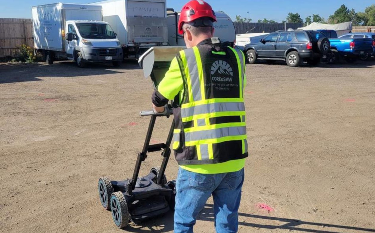
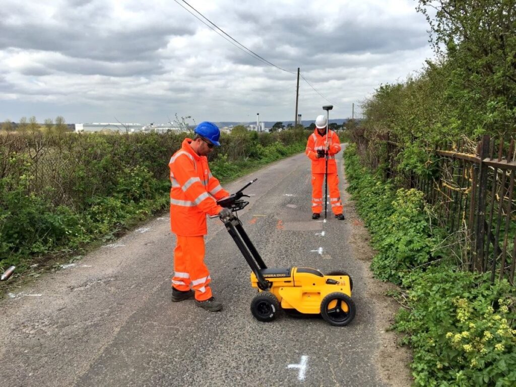
After compiling existing data, ground-penetrating radar (GPR) and electromagnetic locating technologies are commonly employed to locate underground utilities accurately. Ground-penetrating radar uses radar pulses to image the subsurface, providing real-time information about utility locations and depth. On the other hand, electromagnetic methods utilize the detectable electromagnetic fields generated by the utilities themselves, helping precise identification and mapping.
Once the data is collected, it must be compiled into a format that is easily interpreted by all stakeholders involved in the project. High-definition mapping systems that produce 3D models or detailed schematic representations enable project teams to visualize the positioning and relationship of utilities with their project plans. This visualization is not only beneficial for current projects but also serves as a valuable resource for future developments, allowing for better planning and coordination.
Benefits of Implementing Utility Mapping
The benefits of implementing utility mapping are not limited to accident prevention. Enhanced project efficiency is another significant advantage. Utility mapping aids in accurately diagnosing the complexities of site conditions beforehand. This effectively reduces unforeseen circumstances that could delay the project timeline. With precise knowledge of existing infrastructure, project managers can devise apposite strategies, allocate resources wisely, and streamline project timelines.
Moreover, utility mapping enhances cost management by mitigating unforeseen expenses associated with accidental utility strikes, rework, and delays. For construction companies, the cost of accidents can be substantially higher than the investment in utility mapping. This proactive approach saves time and money in the long run, thereby increasing overall profitability. Additionally, utility mapping can foster better communication among various stakeholders, including engineers, contractors, and utility providers, facilitating a collaborative environment that promotes efficiency and innovation throughout the project lifecycle.
Furthermore, the integration of utility mapping into the project planning phase can lead to improved environmental sustainability. By accurately identifying utility locations, project teams can minimize disruption to existing ecosystems and reduce the carbon footprint associated with construction activities. This aspect is particularly crucial in sensitive areas where preserving natural habitats is a priority. As urban development continues to expand, the role of utility mapping in promoting responsible construction practices cannot be overstated, making it an essential component of modern infrastructure projects.“` Want to get about the importance of construction surveys Visit https://ensureal.com/the-importance-of-construction-surveys-in-civil-engineering/.
Technological Innovations in Utility Mapping
With the introduction of advanced technologies, the landscape of utility mapping continues to develop. Geographic Information Systems (GIS) have become a staple tool for managing and analyzing spatial data overlaid on maps, facilitating the integration of utility data with project plans. Utilizing GIS technology, teams can create more dynamic and interactive representations of utility locations, enhancing communication among stakeholders and facilitating more effective planning. This capability not only streamlines workflows but also allows for real-time updates, ensuring that all parties have access to the most current information, which is crucial for timely decision-making.
Furthermore, drone technology has started to play a vital role in utility mapping. Drones equipped with various sensors can capture aerial imagery and spatial data, offering comprehensive insights into site conditions. This innovative approach reduces the time spent on-site and increases data collection efficiency, particularly on larger sites that may have complicated utility layouts. The ability to conduct aerial surveys also minimizes the need for manual inspections in hazardous areas, thus enhancing safety for workers and reducing project downtime. As drone technology continues to evolve, we can expect even more sophisticated applications, such as thermal imaging and LiDAR scanning, which will further improve the accuracy and detail of utility mapping.
Lastly, the integration of artificial intelligence (AI) in utility mapping can help refine data accuracy and predictive analysis. AI algorithms can analyze vast amounts of data from various utility services, pinpointing potential conflicts and improving the reliability of utility records. These technologies not only enhance the accuracy of utility mapping, but they also contribute to effective decision-making processes, driving project success. Machine learning models can even predict future utility needs based on historical data trends, enabling proactive planning that anticipates growth and infrastructure demands.
The Future of Utility Mapping
As project complexity increases and technological innovation accelerates, the future of utility mapping looks promising. With greater emphasis on digital twin technology, where virtual representations of physical assets are used, utility mapping will be pivotal in the planning and management of infrastructure assets. The integration of real-time location data and monitoring systems will permit project teams to remain proactive about potential utility-related issues throughout the lifecycle of a project. This capability not only enhances operational efficiency but also supports sustainability initiatives by allowing for better resource management and reduced environmental impact.
Moreover, as governments and regulatory bodies enforce stricter directives regarding underground utility management, the need for diligent utility mapping will only grow. Project managers will need to prioritize utility mapping at the preliminary stages of any construction endeavor, ensuring that they meet compliance obligations while also safeguarding their workers and the public. The rise of smart cities and the Internet of Things (IoT) further emphasizes this trend, as interconnected systems will require precise utility mapping to function effectively. As cities evolve into more technologically integrated environments, the demand for accurate and accessible utility mapping will become increasingly critical, shaping the future of urban planning and infrastructure development.
In addition to these advancements, the ongoing collaboration between utility companies, construction firms, and technology providers will be essential in driving innovation forward. By sharing data and insights, these stakeholders can develop more comprehensive mapping solutions that address the unique challenges of each project. As the industry embraces a more collaborative approach, we can expect to see enhanced tools and methodologies that not only improve utility mapping but also contribute to the overall resilience and efficiency of our infrastructure systems.
Leave a Reply